
Dave’s Journey to the Northwest Passage
September 9, 2025 - Nome, Alaska - Final Post
My voyage through the Northwest Passage ends today in Nome, Alaska. I’ll hop on an airplane to Seattle, Washington. After spending a few days there, I’ll fly home to Toronto on September 12th. So, this will be my last blog post. Here are my final thoughts and people to thank.
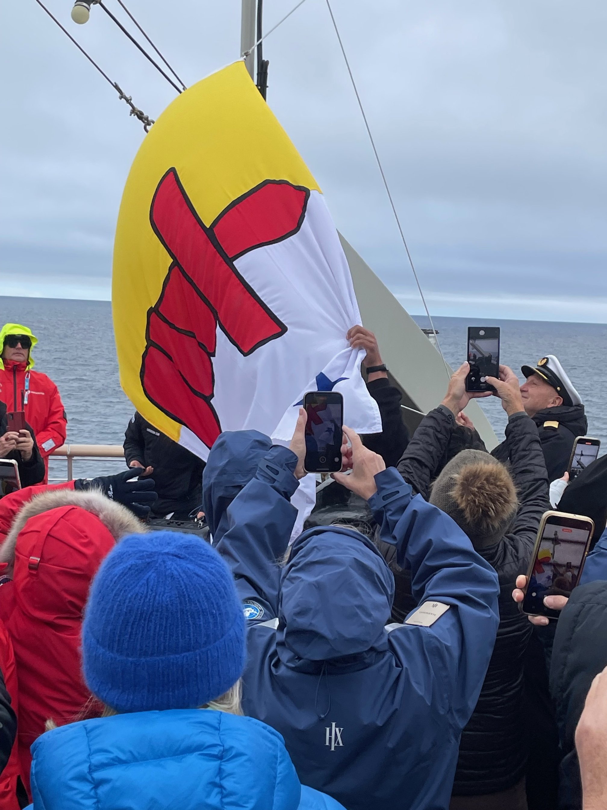
But not before I let you know that at about 3:30 pm yesterday, we passed Big Diomede Island (Russia) and Little Diomede Island (USA).
First of all, a big thank you to Tristan Cuschieri. Tristan uploaded my blog posts and photos, and made sure all the formatting worked. As we talked online daily, he provided a great source of feedback. “Tristan – thanks”.
Thank you to everyone who emailed me with comments and reactions to posts. It’s nice to have fellow travellers, even if virtually. The crew of the MS Fridtjof Nansen have been fabulous. Our captain, Frank Martinsen, and bridge officers kept us safe. The science, hospitality, and zodiac crews made the trip much more interesting than I could even imagine.
The food was great. The housekeeping staff made sure my needs were met. They also did double cleaning duty to help passengers suppress colds, the flu, and the COVID virus. Staff commitment to environmental sustainability was exceptional.
I’m so pleased that Hurtigruten Tours asked Inuit cultural ambassadors onboard. The Ambassadors were generous in sharing of information about their lives, and the lives of people in the Inuit communities. The Inuit people we met in each community were friendly and anxious to talk to us. There were so many children giving us welcome waves. We might have been one of the last of five cruise ships this season. But that only strengthened their desire to interact.
Things I’m thankful for: I saw the grave sites of some of the Franklin crew; I met many wonderful people; I saw a part of the world that few others will ever see; I crossed the Northwest Passage; and I didn’t get scurvy.
Finally, this planet Earth is so large. The vastness of Canada and the north humbles you. The High Arctic is so remote. It’s authentic, rugged, and beautiful. I only wish you could have travelled with me. But for now, I hope, as a virtual traveller, you’ve been able to see this part of the world through my eyes.
Best, and God bless.
Dave
September 8, 2025 - Bering Strait
This morning, the seas are calm and it’s foggy. The interesting thing is, the coast of Russia is showing up on my in-cabin TV screen map. My coordinates are 67° 13’ north latitude and 168° 36’ west longitude. This meridian mainly passes through Eastern Russia and the Pacific Ocean. But in the southern Pacific, it passes through Fiji. We are preparing to leave in Nome, Alaska tomorrow.
Big Diomede Island, Russia.
Little Diomede Island, USA.
I’m five hours behind Toronto and Fort Myers, Florida. In about an hour, we will cross the International Date Line (to tomorrow), then go back across the date line to today. I hope that isn’t confusing. I just go where and when they tell me.
I’ve learned a lot, and I’ve tried to share it with you through my daily posts. I wish I could have shared more stories of the people who take ‘expedition-type’ cruises. I met people who travel seriously.
I overheard a solo traveller say he had just left a 106-day around the world cruise before joining this one. After Seattle, he will spend the next month touring the US.
I had lunch with a man who was planning a camper van trip along the Silk Road – Beijing to the ’…stans.’ But he first had to finish his drive along the Pan American Highway – Alaska to Argentina. He said his camper was shipped to Montevideo, Uruguay from Panama.
I had dinner with an American lady who travelled to 100 countries. She’s been on the Trans-Siberian Railway, vacationed in Iran, and talked to me about whether the Bolshoi Ballet in Moscow was better than the Mariinski Ballet in St. Petersburg. I couldn’t contribute much to the conversation.
Most passengers are retirees, with some middle-aged people who managed to carve out this time in their lives. Many are staying on for a cruise along the Alaska coast, then British Columbia’s inside passage and onto Vancouver. This is not, nor has it ever been, nor will it ever be my world. But it is interesting to see how these folks live their lives.
Each afternoon, we are treated to music by onboard pianist Derek Conlon. Derek performed with top musical acts, including Tom Jones, Elton John, and Oasis. He’s also author of Sea's the Moment, about cruise ship work after being near death at the hands of international spies. Have a listen: https://www.youtube.com/watch?v=p8tMx-KIxSk.
September 7, 2025 - Approaching the Bering Strait
This morning, the seas are calm. The MS Fridtjof Nansen is headed southwest past Wainwright, on the north slope of Alaska and toward the Bering Strait. Our latitude is 71° 26’ north, longitude 157° 37’ west. The closest American city at this longitude is Honolulu, Hawaii.
I’m looking forward to traversing the Bering Strait. The strait links the Arctic Ocean to the Bering Sea, and north Pacific Ocean. At its narrowest point, the Bering Strait separates the United States and Russia by 88 kilometres. The closest point is Little Diomede Island, USA in the middle of the Bering Strait. It is about four kilometres from Big Diomede Island, Russia.
This morning, I saw a pod of walruses off the bow. Other guests spotted whales - not me. So, I spent much of my morning on a nature watch to see if I could see them, and after dinner, I did. At around 7:00 pm, hundreds of short tailed shearwaters were landing as if roosting. In the middle were three humpback whales. It looks like the whales stir up the krill as they are eating, creating a mid-ocean feast.
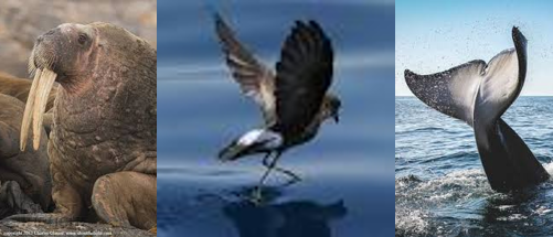
Image credits: Pinterest
Over the last couple of weeks, I’ve learned a lot about the circumpolar interactions of the Inuit people.
Folks in closest proximity to me are the Yup’ik. The Yup’ik are indigenous people living in western and southwestern Alaska. They are known for story telling, intricate masks, and drum dancing. Some of their traditions are similar to the Siberian Inuit.
Pamyua is one of Alaska’s most famous Yup’ik music groups. They blend traditional Inuit music with Yup’ik dance performance. Out of Anchorage, they combine their Yup’ik Inuit and Scandinavian-Greenland heritage. Their most famous (and fun) song is Bubble Gum’. Have a listen: https://www.youtube.com/watch?v=d7IUUbS3GkE.
September 6, 2025 - Beaufort Sea, Alaska
It’s a sunny Saturday morning on the Beaufort Sea. I’m about 70 Kilometres off the coast of Alaska, passing Prudhoe Bay. Precisely 70° 47’ north latitude and 147° west longitude. The only North American cities at this longitude are Anchorage and Fairbanks, Alaska.
I kind of wish we were closer to the shore to see Prudhoe Bay. However, even at 70 kilometres out to sea the ocean is rather shallow, at a depth of 43 metres – to put it in perspective, the height or depth of a 14-floor apartment building. Depths on most of the other parts of the passage have been in the range of 300 to 500 metres. So, we need to be here.
We are about 1,300 miles from the geographic North Pole. Our voyage from Cambridge Bay to Nome, Alaska is about 1,500 nautical miles, or 1,726 miles. In comparison, crossing the Atlantic to London from New York City takes six to eight days, over 3,300 nautical miles or 3,800 standard miles.
I am curious about the Alaska communities we are passing. Prudhoe Bay is the location of North America’s largest oil field. Oil is transported 800 km to Valdez, Alaska via the Alaska pipeline.
Scattered along the shore are small Inupiat-speaking Inuit communities that have been here for many millennia. The language difference is like the difference between Bronx English and Liverpool English. Here, the word ‘caribou’ is ‘tuttuvak.’ Further east, it is ‘tuktu.’ They traditionally survived through fishing and whaling. Today, they make sought after parkas. The communities are much larger than the Northwest Passage communities we just visited. Utqiagvik (formerly Barrow) has a population of 4,900. It provides cargo and ship services. The Town of Kotzebue has 3,000 people.
I continue to talk to the other passengers. Two Swedes know I’m Canadian. They are quite eager to chat, as they are hockey fans. They tell me about all-time NHL Swedish greats, including Nicklas Lidstrom, who played on the Stanley Cup winning Detroit Red Wings. Also, the late Toronto Maple Leaf Borje Salming, who died in 2022 at the age of 71. He was the first great Swedish NHL hockey player.
One of the Swedes was on the medical staff for the Toronto Maple Leafs. She worked with Brian Burke, who was General Manager of the Leafs between 2008 and 2013. Given that the Leafs have not won a Stanley Cup in 58 years, I think they were also trying to cheer me up. “Hey Dave… next year for sure.”

Image credit: thevarsity.ca
I’m trying to think of a great photo. But all I see is water.
September 5, 2025 - Beaufort Sea
This morning, the ship is about 100 km offshore, cruising west in the Beaufort Sea. We are at 70° 26’ north latitude and 133° 58’ west longitude. This places us north of the Mackenzie Delta, Tuktoyaktuk, North West Territories and Juno, Alaska. The rest of the meridian goes through the Pacific Ocean.
Tuktoyaktuk welcome sign in front of the Arctic Ocean.
The Beaufort Sea is known for being cold. This morning lives up to its reputation. The sea is named after the British scientist Sir Francis Beaufort (1774 – 1857), who invented the Beaufort scale. It’s a scale for calculating wind speed depending on how the sea looks. ‘1’ on the scale means a calm sea, while ‘12’ indicates a hurricane force wind. It’s currently blowing at 15 knots, or 18 miles an hour – Beaufort Force 4.
I’ve been waiting for this day. It gives me the opportunity to share the journey to Tuktoyaktuk ‘Tuk’ with my daughter, who made it in 2018. In fact, standing at the Arctic Ocean got me curious about what lies east and west. This curiosity is probably the main motivation for me travelling the Northwest Passage.
Canada’s only road to the Arctic Ocean was completed in 2017. It is called the Dempster Highway. It’s basically a 900-kilometre dirt road going north from Dawson City, Yukon. My trip involved flying to Calgary to meet my daughter; flying to Whitehorse, Yukon, where we rented an SUV sized car; then driving to Dawson City, Eagle Plains, Northwest Territories, Inuvik, and then to Tuk.
Diamond Tooth Gerties in Dawson City.
Some highlights: as I left the 90° Toronto summer heat, the looks I got carrying a winter coat; getting coached on how to drive the Dempster by the Northwest Territories information centre staff; crossing the two mountain chains; crossing the Peace and Mackenzie rivers by car ferry; the challenge of driving over mud covered ice; the permafrost and pingos (ice mountains); the day spent in Inuvik; and finally, reaching the Arctic Ocean. In Tuktoyaktuk, we bunked at the teacher’s residence, as tourist lodging was not available.
While the vistas were magnificent, my daughter would probably say my highlight was the evening I spent watching can-can dancers at Diamond Tooth Gertie’s Hotel in Dawson City. She pointed out that 20 percent of my photos were taken there.
As the Dempster Highway was just opened, there were very few travellers. In fact, we’d sometimes drive an hour without seeing another vehicle. Because of this, we stopped to see if help was required when we saw a car or camper van that slid off the road. We saw several brave souls trying to do the Dempster by motorcycle, and one by bicycle. Given the difficulty and swarms of bugs attacking you when you stopped, I had no idea if they made it.
As the evening ends, the MS Fridtjof Nansen is about to cross from Yukon to Alaska through a snow storm.
September 4, 2025 - North of Cape Parry, Arctic Ocean
Arctic ice pack.
A polar bear eating a seal.
And now, something completely different.
This morning, we reached 70° 19’ north latitude and 123° 48’ west longitude – north of Cape Parry, Northwest Territories. This places us directly north of Victoria, British Columbia and San Francisco, California.
Just before dawn, we encountered a massive ice pack. The ship slowed from 16 knots to 2 knots, and then 1 knot. Basically, dead slow as we headed through the ice. On my MarineTracker app, I see that there is an icebreaker about 300 kilometres to our west. Not sure if we will need it.
Last night, the captain broadcast that we would no longer have stops and would be heading directly to Nome, Alaska. With the time challenge of ice, I can understand why.
As the MS Fridtjof Nansen is a Polar Class 6 ship, the hull is designed and constructed to cross new ice and push ice growlers and bergy bits out of the way. But to me, the process of doing so is a bit unnerving. The larger ice patches are massive. When the ship encounters them, the ship shakes and sometimes comes to a stop.
For the last two weeks, my fellow passengers have complained about global warming and ice-free seas. They asked, “Where’s the ice that impeded Franklin and his rescuers?” Now they know.
So far, today’s highlight is seeing a polar bear eating a seal. The kill site was marked by a lot of blood. As we approached, he carried the carcass away from the ship by jumping on ice flows. At about 8:00 am, the ship turned south to get out of the ice pack. By 10:00 am, we are nearer to the coast and in ice-free waters.
The Smoking Hills.
But after two hours, we are back in the ice pack. I attended an ice navigation lecture. In addition to sonar, radar, and satellite images showing where the ice is, six ‘ice-licenced’ crew have to be on deck at all times.
At about 3:00 pm, while sailing northwest in Franklin Bay and along the shore of Cape Bathurst, we came across an incredible natural phenomenon called the Smoking Hills. This is an area of oily shale that is rich in sulphur. When exposed to air, it combusts.
It has been burning for thousands of years.
September 3, 2025 - Ulukhaktok, Northwest Territories
The MS Fridtjof Nansen sailed west for the last 22 hours. We’ve anchored off the Gulf of Amundsen, the west side of Victoria Island at Ulukhaktok, Northwest Territories. At 77° 43’ north latitude and 117° 46’ west longitude, San Diego, California and Cranbrook, British Columbia are due south.
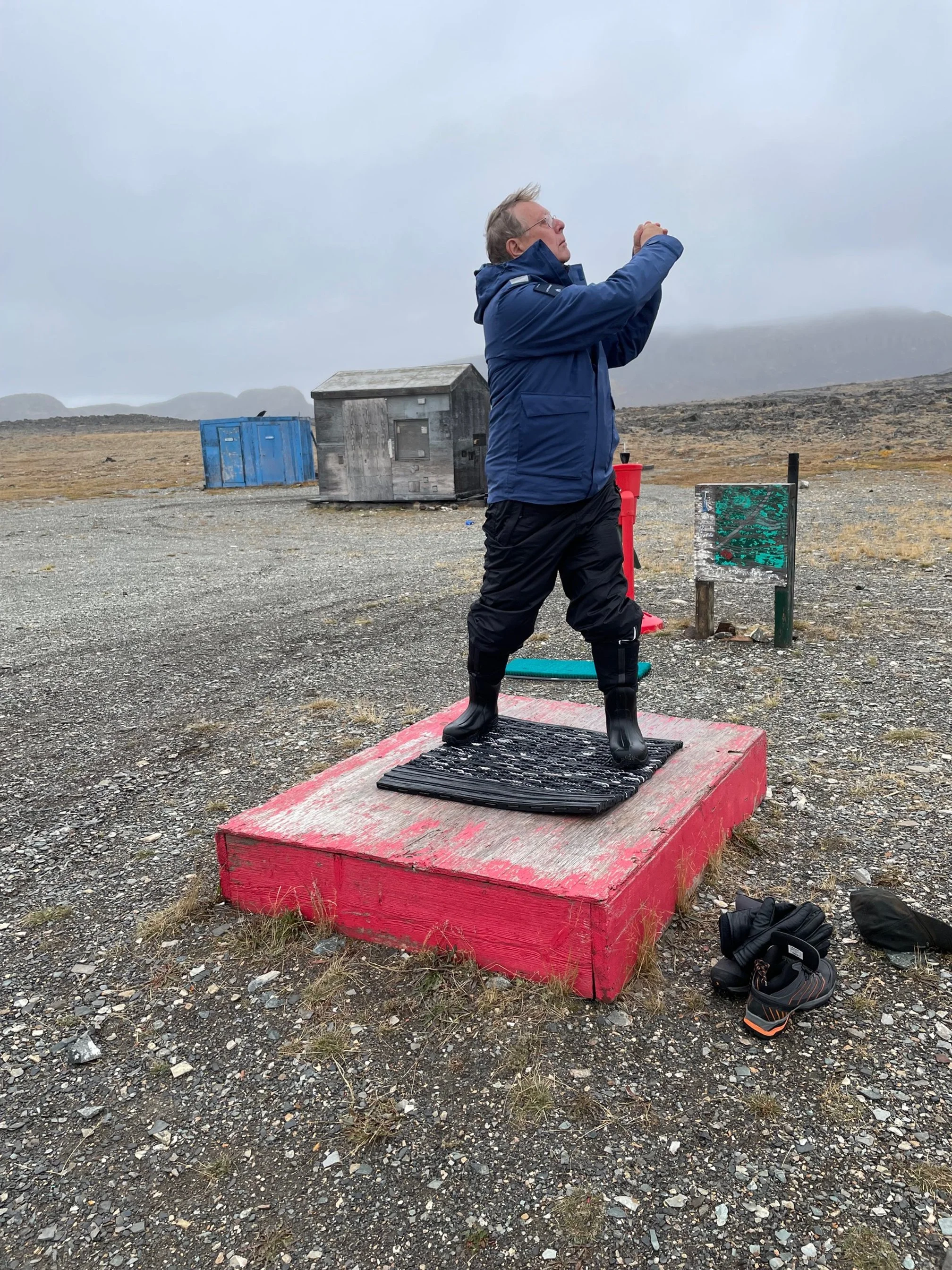
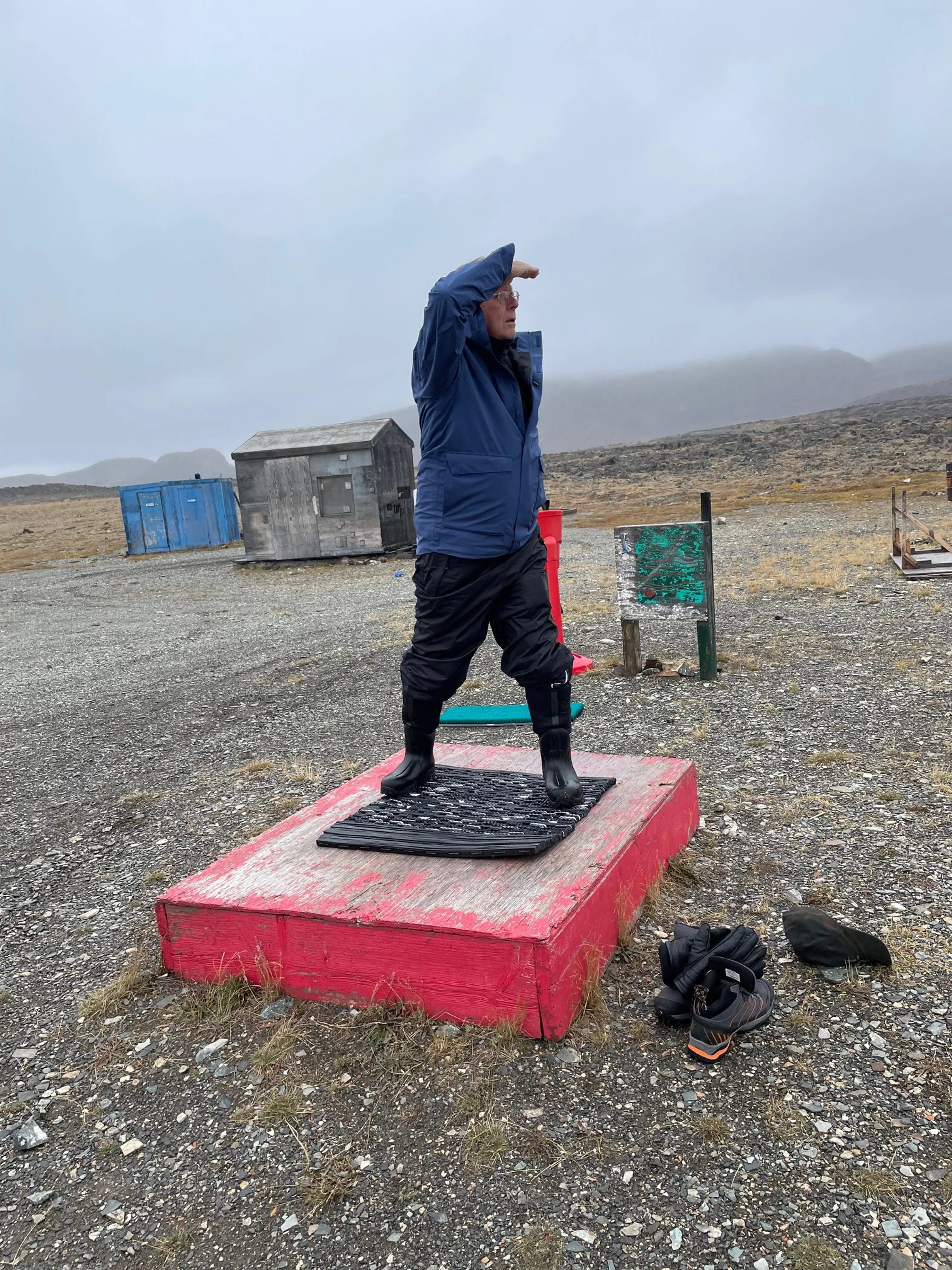
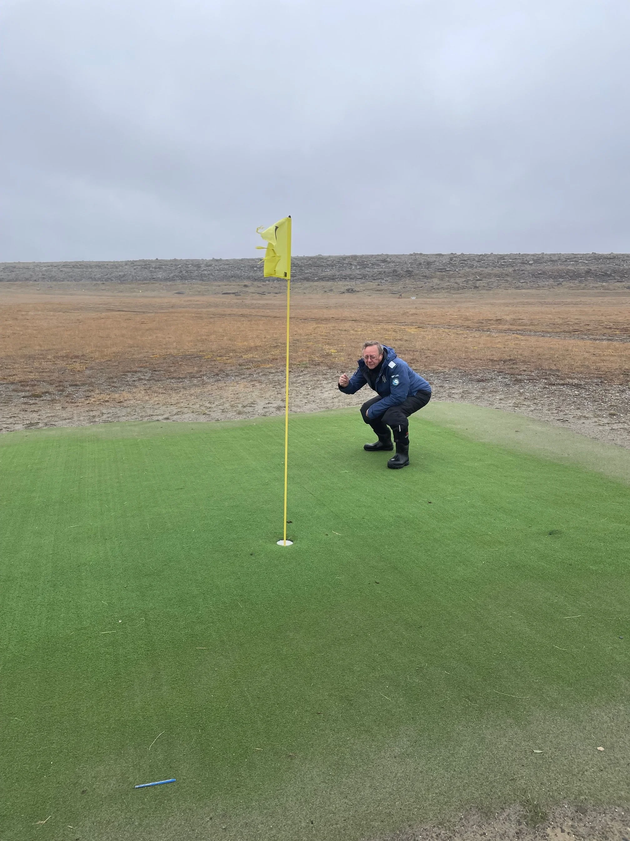
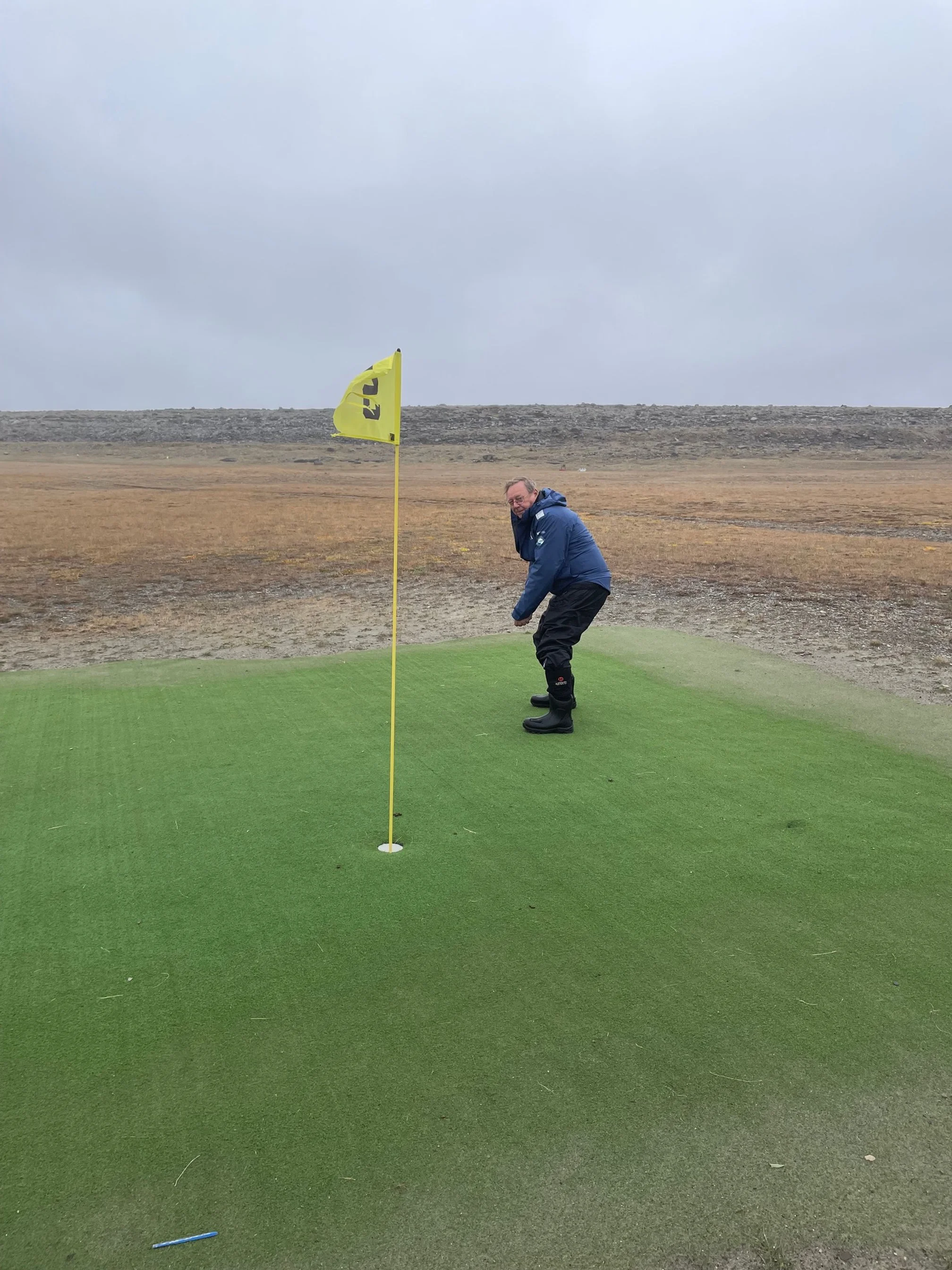
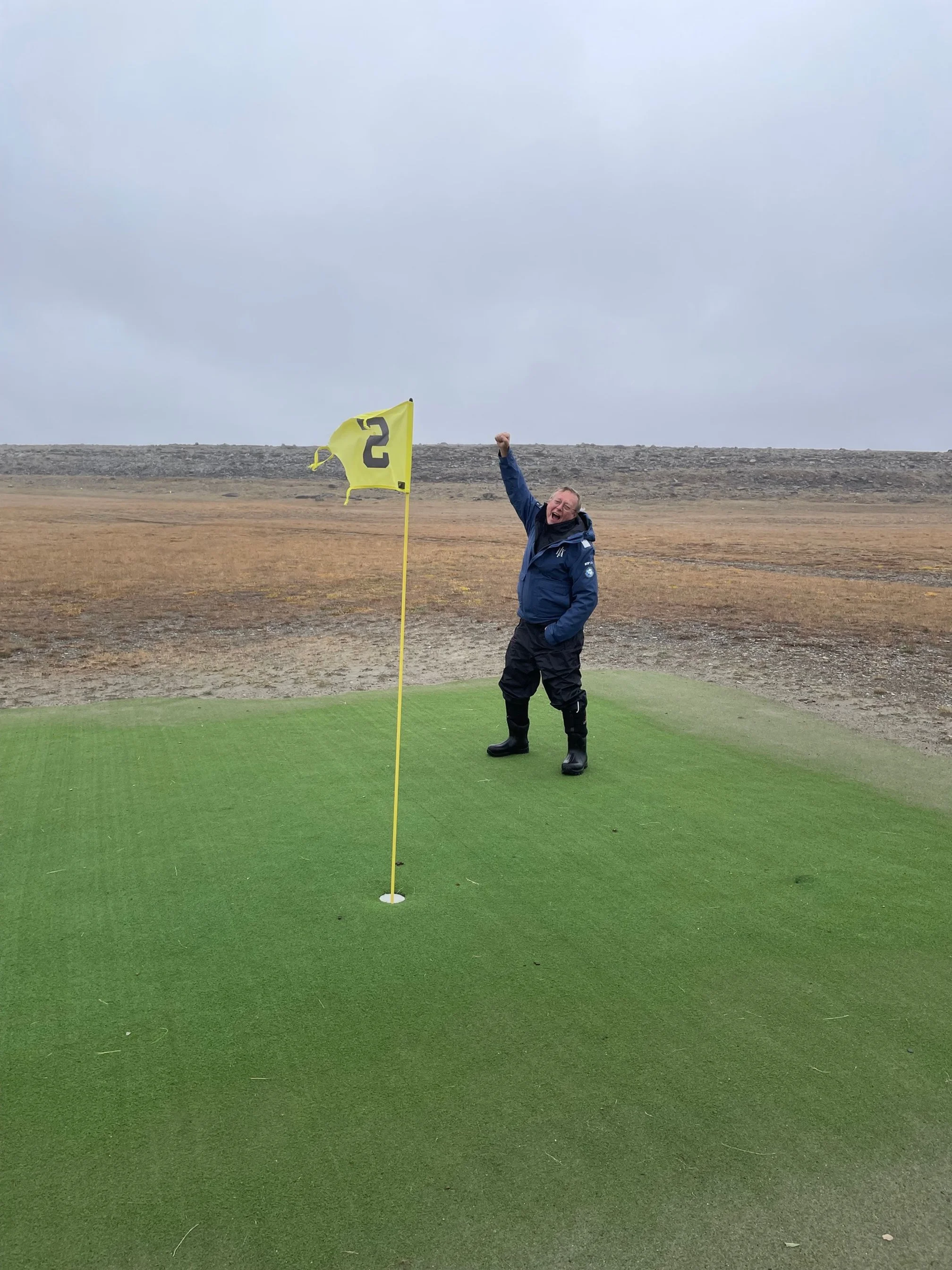
Ulukhaktok is a small community of 500 Inuvialuit Inuit. They are also known as Copper Inuit because they found and worked with copper in the area. It was visited by a European Franklin search party in 1853, and they gave the community the name Holman, after one of the crew. Community members are known for their exceptional printmaking, and for having the world’s most northern golf course. What?
I had to try to play a round of golf. Thinking that I could rent a set of clubs, I went to the ship’s registration desk. And, indeed, they had started a list of golfers. Once anchored, we were first off the ship and met by a six-passenger van.
Just as I got in, the driver informed us there were no clubs available, and no golf balls. We went anyway.
The nine-hole course is situated on a rather flat gravel area with Arctic plants making up for fairways. No sand traps. You tee off on a rubber mat, and the green is a patch of AstroTurf.
There is an equipment storage building beside two outhouses. The course was open, and ball washers and flags could easily be seen. As you can see from the photos, I gave it a try. Without clubs and a ball, I’m happy to say it was my first ever bogie free round.
I returned, went to the community centre, and bought a souvenir. I sat close to an Inuit woman, and we talked about grandchildren. The Anglican Church of the Resurrection was open. I went in, sat down and said a prayer, and put some money on the collection plate.
I was fascinated by the scriptural embroidery adorning the walls. The Minister comes once a month, and there was a paper sign posted saying there would be baptisms later in the month. The banner, Matthew 11:28 in Inuktitut, reads, "Come to me, all you who are weary and burdened, and I will give you rest."
Having a rich cultural tradition, it’s no surprise to learn of The Jerry Cans, a Juno award nominated folk group originating from Ulukhaktok, and also based in Inuvik. They sing in English and the Inuinnaqtun Inuktitut language. Have a listen to “The Northern Lights”: https://www.youtube.com/watch?v=puySf5G-KpU.
September 2, 2025 - Duke of York Archipelago
We anchored this morning at Murray Island. Latitude 68° 26’ north and longitude 111° 7’ west. We’re still well north of the Arctic Circle. Directly south: Phoenix, Arizona; Salt Lake City, Utah; and Fort McMurray, Alberta. While slightly overcast, the sun is out and the scenery is great. I decided to go sea kayaking.
Heading to Murray Island (credit: Jan Jaeger)
Kayak training (credit: Jan Jaeger)
I welcomed the opportunity to take a training course and get fitted into a drysuit, a warm jumper under the drysuit, and kayak boots. The drysuit has neoprene at the hands and neck area to prevent water coming in. Otherwise, everything else is sealed and dry.
Our guide checked to see if the neck size was ok. Frankly, the neoprene was choking me, and the process of pulling it over my head was like being reborn – in the physical sense, not the spiritual sense. I told him it was strangling me, and he said if I was able to speak, it fit fine.
Since we would be entering the kayaks from a zodiac while in swells at sea, we saw a short video on how to get out of the zodiac, then into the kayak and back to the zodiac, without falling into the water. Quite precise moves. Since I was nominated as captain of the two-person kayak team, I was also taught how to use the rudder with foot pedals. And that was that.
The kayaks were tied together, then towed far away from the ship to a bay with smaller swells. I entered the kayak with a wonderful German partner who was responsible for navigation. We got to go where we wanted, so long as we stayed within a perimeter defined by the crew, indicated by their kayaks.
Hardy and Jaeger kayaking (credit: Jan Jaeger)
My partner, who was an accomplished and experienced kayaker, decided that we should be the lead kayak and rowed us into the heavier swells. I stopped paddling and simply held on, until one of the crew told us to return to the pack.
We paddled for about two hours, keeping about 100 metres off the shore. One of the crew checked in on us. My partner said we were fine. I said my hands were freezing because my cotton gloves were wet. I was given a set of mittens especially designed for kayak paddles and my hands got warm.
We kept following the lead crew kayak. I started thinking kayaking two to three hours first time out is going to hurt… The crew came over again and asked if we had enough. I said yes.
We were the first team to go alongside the zodiac. My partner performed a precision exit and sat down in the zodiac. I, on the other hand, rolled over the side of the zodiac and flopped into its floor. Both crew members laughed, and my partner said it was the worst exit from a kayak he’d ever seen. Russian judge.
September 1, 2025 - Arctic Ocean
Taking on supplies.
Another change in plan. This morning, we were still in Cambridge Bay. The crew explained that our trip through the Northwest Passage is one of the longest voyages of the MS Fridtjof Nansen. At this point, they need to resupply the food. They also made an off-the-cuff remark about not wanting the passengers to eat one another.
An airplane loaded with six pallets of food and other supplies was supposed to have arrived yesterday, but it was delayed due to strong winds. I checked my Flightradar24 app, and a Canadian North flight has landed. It’s a two-hour flight north from Yellowknife. In short order, two cube vans showed up at the beach, and food is being loaded onto two zodiacs.
Northern Lights.
While waiting, the Norwegian members of the hospitality crew decided that we had still not experienced enough of Norwegian Roald Amundsen. They scouted where his ship, the Maud, had sunk – but was partially submerged – until a few years ago when the government of Norway decided to haul the wreckage back to Norway and place it at the museum for this national hero.
They set up the zodiacs to take passengers where the wreck had been for 90 years. While there was nothing there, the plan was to look at the water, and perhaps say a prayer; then, go to a small church (which was closed) and visit a cairn – no plaque; then, come back. I passed.
By 12:30 pm we were on our way, and by 1:30 were back into the Arctic Ocean. We will be passing Dease Strait, Coronation Gulf, Berens islands, and Simpson Bay on the way to the Duke of York Archipelago. The crew said parts of our voyage will be through shallow waters.
View of the Northern Lights from my cabin.
However, by 2:00 pm we had stopped again. It seems that the hospitality crew decided that the morning shore activities weren’t enough. They learned that we would pass an island that had a beach. The water was apparently shallow enough to have a polar dip. My group was one of the first to be called.
I was faced with a dilemma. I did bring my bathing suit, but with the thought that I’d have a dip in the hot tub. I had to face this decision before. Indeed, I had held the record at the Deception Island polar plunge last year during my trip to Antarctica. I was MS Fridtjof Nansen’s most cowardly passenger of all time, having put my foot in the water for less than two seconds.
So what would it be? Make amends? Show my courage? Take pride in overcoming my fear? Be a man? Or join the other passengers on deck 10 with a glass of wine in my hand?
Australia’s Penfolds, Koonunga Hill, Shiraz (2023 vintage) has a lovely, subtle oak taste. Fine tannins frame its generosity, and it delivers lasting quality with every sip.
Just before midnight, I heard God saying, “You haven’t lived enough today. Go outside and see my Northern Lights.”
August 31, 2025 - Cambridge Bay
Muskox metal sculpture.
After consultation with the Canadian Coast Guard, the crew decided that we could go ashore. It’s quite cold and windy. The weather report calls for snow in the afternoon.
I’ve signed up for a two-hour hike. Instead of going ashore in the morning, I’ve opted for just the afternoon hike. Six hours ashore in freezing conditions might be a novelty to the Australians and Europeans, but I’m going to experience the cold all winter.
Eighty percent of Cambridge Bay’s residents are Inuinnaqtun Inuit. Their writing is westernized – rather than symbols. The community is named after Prince Adolphus, Duke of Cambridge.
Hudson’s Bay buildings in Cambridge Bay.
The traditional Inuinnaqtun name for the area is Iqaluktuuttiaq, meaning “good fishing place.” It’s located on Victoria Island, the eighth largest island in the world – it’s basically the size of Great Britain. It has been settled for 4,000 years, being an excellent hunting and fishing spot. Early European visitors searching for the Northwest Passage include Thomas Simpson in 1839, and John Rae in 1851.
Both the RCMP and Hudson’s Bay Company started an outpost here in the 1920’s. The buildings are still standing. This is also the place where Amundsen abandoned his ship, the Maud. Prominent is the DEW line station and Canadian High Arctic Research Station. It is the administrative and transportation hub of the Kitikmeot region of Nunavut. It has about 2,000 residents, and a new housing subdivision is planned. It has a KFC and a Pizza Hut, so it is prosperous and growing.
Tanya Tagaq (credit: The Walrus)
In the afternoon, I went ashore. I was greeted by local families at the Red Fish Arts Studio, and treated to a sample plate of Arctic Char, a muskox mini burger, and Beluga Whale muktuk. I’d always wanted to try whale meat. It was chewy. About 30 of us went on a 5½-mile hike. It was windy with biting snow on the way uphill. We got out on the tundra and I saw lemming holes, and some small animal skeletal remains. The walk back was much easier.
Tanya Tagaq is a prominent Cambridge Bay ‘punk’ throat singer-songwriter, and avant-garde performer. She won both a Juno Award and Polaris Award, and is a member of the Order of Canada. Through YouTube, I listened to part of her 2019 performance at the Kennedy Centre in New York City. Her music may not be for everyone, but it’s powerful, uninhibited, authentic, and makes you think. Have a listen to Snowblind: https://www.youtube.com/watch?v=KaXh5FsqscY.
August 30, 2025 - Queen Maud Gulf
Last night, we passed the location of Franklin’s two ships, the Erebus and Terror, making this the most westerly point of the Franklin expedition.
Today, there’s been a change in plans. The early morning seas were calm with sunny skies, but after two hours the wind picked up to 15 knots with strong swells and whitecaps. We were going to visit Jenny Lind Island. The island was named after the Swedish opera star (1820 – 1887). As the wind was too strong for the zodiacs, we sailed by.
At 9:30 am, the captain called passengers to deck 10 to announce that we are headed to a safe harbour at Cambridge Bay. Pointing to PowerPoint weather maps, he said winds will shortly pick up to 30 knots, and to 50 knots by noon. This is classified as gale force wind. He said, “You are in the Northwest Passage, and this sort of weather can be expected.”
Prince Leopold Island bird sanctuary.
Since the entrance to Cambridge Bay is shallow and narrow (80 to 100 metres), we will wait outside the entrance for the first storm front to go through, and then try to make our way through the channel before the next front, probably this afternoon. The Bay will provide for calmer seas.
From my own travels with my father and brother on Newfoundland ferries and coastal boats, I understand the respect that captains give to the sea. I travelled on the Northern Ranger along Newfoundland’s south coast, and the MV William Carson in the 1960’s.
The Carson was a large, ice breaking class car ferry. In its early days, it travelled between North Sydney, Nova Scotia, and Port Aux Basques Newfoundland. It was reassigned to the seasonal Labrador coastal service in 1976. In 1977, it sunk after hitting an iceberg 12 nautical miles off Battle Harbour, Labrador. Everyone was rescued.
Qulliq.
Coincidentally, Battle Harbour is where my grandmother’s ancestors have lived for generations. The Battle Harbour Historic Trust was given the fishing premises and other properties on the island. The properties are preserved, and the community operates as a museum. Today, my cousins are very much involved in keeping this National Historic Site a place of importance.
I’m generally comfortable in strong seas, but just in case, I took a gravol pill.
By 12:30 pm, we had arrived in Cambridge Bay at 69° 06’ north latitude and 105° 02’ west longitude. I’m due north of Denver, Colorado; Las Vegas, Nevada; and Lloydminster, Saskatchewan. We’ve been ordered to stay on the ship until tomorrow.
August 29, 2025 - Gjoa Haven, Nunavut
We sailed all night and arrived in Gjoa Haven early this morning. I’m at latitude 68° 37’ and longitude 95° 53’. Gjoa Haven is on King William Island, and is a prosperous Netsilk Inuit community of about 1,600 people. A supply ship was being unloaded, and everyone was busy.
A street in Gjoa Haven.
Given the sheltered harbour, Roald Amundsen and crew spent two years here (1903 – 1905). Although being a small Inuit settlement for thousands of years, it was named in recognition of his ship, Gjoa. Thus, Gjoa Haven. Locals call it ‘Jo’ Haven. It’s also a location of one of the distant early warning stations (called the DEW line). The satellite dishes and radar domes are visible from the harbour. While here, Amundsen did astrological observations and found the magnetic North Pole to be south.
At around 10:00 am, the sun started shining, although it remained cold. My cell phoned worked and I called home. It was great to talk to my wife and catch up.
We got into the zodiacs again and headed to shore. Until noon, we walked around in the community and got much needed exercise. A couple of highlights: an Inuit woman, smoking a cigarette, calling to me from her doorway to tell me I was going in the wrong direction – frankly, it’s not the first time someone’s told me that; and two caribou skins on a drying rack, an Inuit salesman trying to get me to buy his caribou bone carvings.
Caribou skins drying.
We were to be treated to a cultural event at the community centre as soon as bingo ended – participation with Jo residents at bingo was another Fridtjof Nansen optional excursion. Given that it was cold and windy, I went in as soon as possible. A lovely Inuit woman – in a red coat trimmed with embroidery and fur, her hat adorned with beautiful beadwork – sat down beside me, and we talked.
She said she loved bingo and plays three times a week. She had recently won $100. Progressively higher amounts can be won as time goes on, up to $1,500. It’s better in winter when the pots are larger. She talked about her family. Five children, 15 grandchildren, and three great grandchildren. She said her great granddaughter kept calling her grandmother anaana (ah-nana) – instead of anaanattiaq (ah-na-na- tiaq), meaning great-grandmother – so she had to teach her. She loved her family. As we should love our families. And, be loved by our families.
A snow vehicle.
I said she looked quite young to have such a large family. She said she uses a good soap and washes her face with cold water, and that keeps her looking younger than 65 years. She also said, since her husband passed, her friends were trying to set her up with another man. She said she was fine living alone.
Other topics we chatted about:
She does a lot of bead work and sometimes sells it, except for crosses, which she keeps. She said to do good bead work, you need to repeat. Do it again until you get it right. Her niece still doesn’t get it. The beads are expensive from the Co-op and Northern Store – she was able to order cheaper beads delivered from Amazon, but the stores were trying to shut down Amazon deliveries. Gold coloured beads are in most demand.
Square dance at the Community Centre.
She said she needs new glasses, but an optometrist only comes to the community once a year. She took off her glasses and showed me her bifocals, which don’t work anymore. While most Inuit are soft spoken, she said she’s one of the loudest in the community. She needs to get the attention of all of her grandchildren and speak to friends who have lost their hearing, and she’s ok with that. She smiled at me and said, “I’m loud and proud.”
Fewer families now spend the summer on the land, even though there is lots of game, being muskox, caribou, polar bear, and seal. Hunters now have to get a tag and register their kills – and, she said, that’s good because it keeps the animals sustainable.
The cultural event started. Many community seniors and children also turned out. We were treated to throat singing, lighting a qulliq, and a square dance. Passengers joined the dancers.
August 28, 2025 - Paisley Bay
Microbryum curvicollum
Rhizocarpon geographicum
Encalypta streptocarpa
Currently, seas are calm. It’s foggy and rainy. I’m at latitude 70° 40’, longitude 96° 29’ – due north of Fargo, North Dakota, and Winnipeg, Manitoba. We’ve gained another hour, as we’re now in the central time zone.
Today, we are headed to Paisley Bay, the place where Sergeant Henry Larsen and the crew of the Canadian (RCMP) ice breaker St. Roch wintered in 1941 to 1942. It was the first eastbound sailing of the Northwest Passage.
Parks Canada states, “The St. Roch made a 27-month voyage from Vancouver to Halifax along the northern edge of the continent. Two years later, she returned to Vancouver via the more northerly deep-water route. Making the east-west journey in only 86 days, the St. Roch was the first ship to complete the hazardous journey in both directions.” Pretty impressive.
Today’s post will be a bit shorter.
I’ve posted the photos of the Arctic flowers that I saw. Apple provided the following possible classifications: Encalypta Streptocarpa, Microbryum Curvicollum, and Rhizocarpon Geographicum.
Tonight, I’m headed due south to Gjoa Haven, Nunavut.
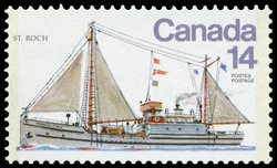
RCMP St. Roch 14 cent stamp.
August 27, 2025 - Somerset Island and Bellot Strait
Midpoint of my voyage.
Today, the seas are heavy with whitecaps – three to four-metre swells. The captain decided to cancel our planned shore excursion to Fury Point. He also cancelled Creswell Bay sight seeing. So, we continue south into the Gulf of Boothia, through the Bellot Strait, and then west to Peel Sound. Having traversed the Drake Passage on the same ship, I’m confident in the ability of the ship and crew.
Perhaps it’s a good day to take stock.
The High Arctic Archipelago is incredibly large and very remote. I suppose, if we needed assistance, another cruise ship or icebreaker would help, but they may be a day away. When I talked to an Inuit security guard at Pond Inlet, he said their nearest large community was Yellowknife, and it may take ten to twelve hours’ flying to get there after landing in other communities along the way. Further west, the residents head to Edmonton.
Bellot Strait.
I think of the many sailors and Inuit guides who died trying to find the Northwest Passage. Hundreds. They gave their lives so that there would be a trade route from Europe to the Orient.
Given the open water, I expected to see commercial traffic. The irony is that the trade route is not even being used. The CruiseMapper app shows six cruise ships in the Northwest Passage, and two icebreakers headed into the Passage from the west.
I had a good chat with the cultural ambassador from Cambridge Bay – she said that, over the last year, she’s seen no commercial ships, nor any Navy ships. The only commercial traffic involves the one supply ship per year.
I expected to see more Canadians. At best, we comprise possibly five to ten percent of the passengers, the Canadian cultural ambassadors included. I’ve met people from Calgary, Montreal, Richmond Hill, and Scarborough.
Fort Ross.
It’s very pristine. I see no evidence of pieces of wood, plastic, or other flotsam and jetsam in the water or on the beaches. And that’s the way it should be.
This evening, we passed through the Bellot Strait. The south side of the strait is the northernmost point of contiguous North America. Specifically, I could theoretically walk home from here. We waited at the east entrance for about an hour until the tidal currents subsided.
Apparently, early explorers failed to pass the strait because of heavy tide currents and ice. The entrance is also the site of Fort Ross, being the last ever trading post for HBC. It was built in 1937 and lasted for eleven years.
August 26, 2025 - Beechey Island
Overnight, we sailed west and stopped at Beechey Island. It has a high promontory of limestone rock. To its north, it levels off and becomes a screed, limestone beach, and slightly elevated pasture-like area. It’s named after Captain Beechey, HMS Blossom. He served with Sir John Franklin in the 1818 North Pole expedition, and was one of the first to realize that the Franklin expedition had not gone well.
At anchor in Beechey Bay.
Out my window, I can see the shallow isthmus connecting it to Devon Island – the largest uninhabited island in the world. It’s a good place to anchor and settle, compared to the cliff-like shore characterizing the rest of Lancaster Sound. It snowed overnight, and the temperature is now at the freezing mark.
Beechey Island is the most visited historical site in the Arctic. It is the place where Sir John Franklin encamped in 1845 to 1846, and where he buried the first three crewmen who died on his final 1846 expedition. It was also visited in 1850 by an American search expedition involving five ships. It was this expedition that found the three crewmen graves and discarded tin cans. The graves provided evidence that the Franklin expedition had continued on.
McClure, the explorer and captain of the Investigator, also visited Beechey Island. The fourth grave is Thomas Morgan, who died in 1854 after serving with him on the Investigator.
The first explorer to completely sail the Northwest Passage was Roald Amundsen. He visited the island in 1903. Thus, I’ve drawn the conclusion that Beechey Island is a sort of pivot point. From here, early explorers had the opportunity to choose several southern routes, or go north to what was then thought to be the open polar sea.
This morning, the first passengers to go ashore were the hikers. They had been warned that the hike had a high level of difficulty. In contrast, I chose to walk the beach as soon as I could get ashore.
The sailors’ graves on Beechey Island.
About 45 minutes after the first passengers reached the beach, a polar bear was spotted. It was headed towards the landing spot, so everyone got back on the boats and headed back to the ship. The bear must have had a taste for senior citizens, as it didn’t stop there, but headed into the sea. The crew decided to bring the zodiacs into the ship and close the hatch. The bear eventually made its way back to shore and proceeded in the other direction.
I finally got ashore and visited the graves. I was happy that crew staff ensured there was proper respect for the gravesites, as it should be for these incredibly brave explorers. At day’s end, I spent half an hour watching a polar bear beachcomb along the shore of Prince Leopold Island.
We head south.
August 25, 2025 - Maxwell Bay
A waterfall in Maxwell Bay.
Well, today we have a change of plans. We were supposed to anchor at Maxwell Island, a small island to the west of Devon Island, but the winds are too strong. The captain decided to pull into Maxwell Bay to get out of the wind. So technically, we are still travelling west in Lancaster Sound. Our latitude is 74° 42’ north and our longitude is 88° 42’ west. Thus, I’m north of Milwaukee, Wisconsin, Mobile, Alabama, and Thunder Bay, Ontario.
The bay has several very high, meltwater-type waterfalls. Great to see and hear.
At about 10:30 am, I got a text from my friend Donna. She said she was on the Ocean Endeavour, in the same bay, about six miles to our south. I’m hoping to see her if the two ships get close. I’ve downloaded the Cruise Mapper app at the suggestion of an Australian passenger named Annie. The position of both ships is quite precise on the app. Shortly later, Donna sent a photo of our ship that she had taken from a zodiac.
The Fridtjof Nansen, from the perspective of the Ocean Endeavour. (credit: Donna Pawlowski)
Late this afternoon, the captain announced we would pass the Ocean Endeavour. I informed Donna through WhatsApp that, when passing, I’d be on the stern of our ship wearing a powder blue t-shirt, and waving. As dinner approached, I decided to dress more formally and put on a white dress shirt.
Halfway through dinner, we were about to pass within 200 metres of the Ocean Endeavour. I left my dining companions and went to the stern. For more visibility, I took off my white shirt and started waving it. I couldn’t see Donna waving back, so I put my white shirt back on and returned to join the three other guests at my table. By then, my food had grown cold.
Dave waving to Donna on the Ocean Endeavour.
About two minutes later, a security guard from the Fridtjof Nansen came into the dining room looking for someone. Then it struck me. I’m guessing he was looking for a man in a powder blue t-shirt.
While I didn’t capture Donna’s attention, I’m pretty sure I caught the attention of the captain and crew of the Ocean Endeavor, who had likely radioed our ship asking if everything was all right. I decided the best strategy would involve putting my head down, finishing my meal, and repacking the powder blue t-shirt.
Important fact: Apparently, flags are used as part of ship-to-ship communication. A white flag in a maritime context traditionally signals a request for truce or surrender, and can also signify a boat needing information or assistance.
A good reference can be found here: https://emed.ie/_docs/MedicoCork-International-Code-Of-Signals.pdf.
August 24, 2025 - Lancaster Sound at Devon Island
After the sun rose at 4:00 am, the weather turned to rain and fog as we sailed west through Lancaster Sound. The Fridtjof Nansen put down anchor off the coast of Devon Island, at Dundas Harbour around 9:30 am. The north shore of Baffin Island is on the other side of the Sound. We are at 74° 32’ north latitude and 82° 25’ west longitude. This far west is due north of Lakeland, Florida and Elliot Lake, Ontario. I’m also about 1,100 miles south of the geographic North Pole.
The Sound is named after Sir James Lancaster, born in 1554. He was a privateer who, in 1601, commanded the first East India Company fleet that sailed to the East Indies. He became very wealthy and was a director of the East India Company.
Mountains of Bylot Island.
As we entered the harbour, we avoided small ice flows, and seals were spotted.
Part of a morning lecture by science staff featured the disease scurvy, that led to the demise of early sailors and ended many expeditions. It involves weakness, anemia, gum disease, sore arms and legs, skin problems, and bleeding – leading to death. Apparently, consuming lemon juice and other fruits and vegetables rich in vitamin C wards off the disease. Tomorrow morning, I think I’m going to order a fruit tray for breakfast.
I continue to try to get to know people onboard. I attended a ‘solo meet-up’ circle session of about twelve people. The staff leader asked us to introduce ourselves. Those who know me well know that I can’t resist a punch line. The two ladies I was sitting beside both said their name was Linda. As I was next, I blurted out that my name was Linda. This got a big laugh from the Americans – but, not the Europeans. Their faces showed shock and bewilderment. A man named Linda? Three Lindas sitting in a row?
Linda number two, an outspoken senior from Kansas City, punched me in the arm and I gave my real name. The Americans laughed again and gave a look that said, ‘I can be friends with that guy.’ Through facial expressions, I could see the Europeans thinking, ‘Why did he have to disguise his name? This is someone I probably don’t want to know.’
I was scheduled to go kayaking this afternoon. I attended a training session and obtained a dry suit. But over the noon hour, the staff informed us that, because the fog was now heavier, the trip was cancelled. We spent the afternoon travelling in and across Croker Bay. I’ve attached a photo of what the shoreline would look like.
If only I could see it.
August 23, 2025 - Pond Inlet, Canada
Inuit qulliq teacher.
Today was poetry. We arrived at Pond Inlet, Nunavut to a slightly overcast day and warmer weather. We are at 72° 42’ north latitude and 77° 58’ west longitude. I’m due north of Belleville, Ontario.
People have lived in Pond Inlet for 5,000 years. About 1,000 years ago, it was settled by the Thule people. The primary language is Inuktitut. Today, I’ve seen and heard Inuktitut written and spoken throughout the community.
While hunting, fishing, and tourism form the economy today, Pond Inlet has always been a centre of Inuit and Western explorer trading. It’s also host to the world’s furthest north Tim Horton’s. Several European travellers heard the Canadians talk about ‘Tim’s’ and they left the tour to find it.
Lip pulling contest.
The snow-capped and glaciated mountains of Bylot Island can be seen across the Bylot Strait. Words don’t quite capture the beauty of the scenery. Perhaps, it’s better spiritually. I thank God for allowing me to see and experience this wonder.
The Inuit have about ten seasons with three months being completely dark. To survive, they use a qulliq – a traditional oil lamp. It has a soap stone base that provides warmth, light, and heat for cooking. I had to step back to fully understand its value to Inuit survival. And, I joined a workshop on how to use it.
Since Greenland, I’ve seen a small, wispy, dandelion-like flower the Inuit call Arctic Cotton. It was already picked for our workshop and handed out. Led by our Inuit hosts, we dunked the Arctic Cotton in vegetable oil (they said any oil, such as seal oil, would do). Each of us formed wicks out of the cotton and set it alight. The Inuit elder I worked with said tending the qulliq also allows her to meditate and remove stress.
This afternoon, we travelled to the Community Centre to learn about Inuit culture. Following the singing of O Canada in Inuktitut, the community performers showed us many types of high kicks and sitting kicks. Young men throughout the Arctic look forward to competing. Ten community members performed a drum dance, throat singing, and, as best as I can describe it, a funny face comedy challenge. The lip pulling challenge could be useful in getting world leaders to communicate better.
We were greeted warmly. Everyone waved and smiled. I particularly remember walking past children playing in a stream that would normally be frozen. All the children were curious. Four young boys surrounded one of the passengers wearing a turban and peppered him with questions.
This evening, we are headed further north, to the entrance of the Northwest Passage.
August 22, 2025 - Second Day on Baffin Bay
Current section of the voyage.
As I start my day, there are calm seas and I can see bit of sun on the horizon. However, it’s very cold outside, and I expect most of the day to be overcast. On the horizon, occasional large icebergs pass.
The MS Fridtjof Nansen is at 71° 57’ north latitude and 68° 51’ west longitude. This puts us due north of Sherbrooke, Quebec. It’s interesting that each day at sea, we’ve gained an hour. This far north, the lines of longitude converge on the North Pole, and thus are closer together. I’ll gain another hour tomorrow.
We are headed west-northwest, basically running parallel to the coast of Baffin Island. Baffin Island is Canada’s largest island, and the fifth largest island in the world at an area of about 570,000 square kilometres. The larger islands are Greenland, New Guinea, Borneo, and Madagascar. The 13,000 residents are mainly Inuit, whose ancestors were Thule. The Thule were skilled nomadic hunters. The economy of Baffin Island includes the Mary River Iron Ore Mine, tourism, hunting, and fishing.
I had lunch with a Kiwi I met earlier. We discussed our families. She was proud of her two children in their mid-30’s. One was a mechanical engineer, his specialty being large aircraft maintenance.
Her daughter was in the final stages of becoming a Vicar. She was about to be married to a church organist, of whom my lunch partner was also proud. I commented that a marriage of a Vicar and church organist was likely to be very long and successful, as they had compatible careers.
Not that I have ever been on a dating web site, but I speculated that when women are selecting the occupation of a preferred partner, church organist was not likely to be on top of the list. She agreed.
At about noon, we raised the Nunavut flag and played the Nunavut anthem as we crossed into Canadian waters. The anthem is a beautiful piece with wonderful harmonics. Beginning with throat singing, it’s sung here by the combined child and adult choirs of Iqaluit, Nunavut. Have a listen: https://www.youtube.com/watch?v=mcQbBLzn7Ak.
August 21, 2025 - Cruising Baffin Bay
This morning, we are cruising Baffin Bay. It’s 1° Celsius. The cruise director told us the seas are expected to be calm on the two-day, 700 km (approximate) passage to Pond Inlet, Nunavut. Pond Inlet is on Bylot Island, which is located off the northern tip of Baffin Island. It is also at the entrance to Lancaster Sound, a key entrance to the Northwest Passage.
William Baffin. (credit: Pinterest)
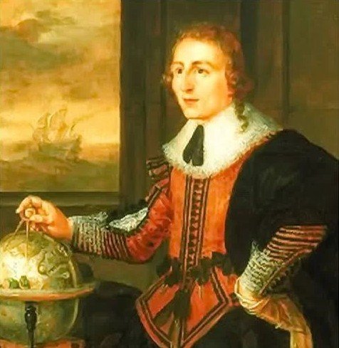
Baffin Bay and Baffin Island are named after early explorer, William Baffin (1584-1622).
Baffin explored at a time when the English, French and Spanish were fighting, making it difficult for the English East India Company to trade with India in the early 1600’s. Finding an alternative trade route to India, Japan and China would make the East India Company rich. Europeans knew of the silk road travels of Marco Polo (1271-1295), and the riches of China. Baffin succeeded the failed Henry Hudson Northwest Passage explorations through Hudson’s Strait and Hudson Bay as early as 1610.
Baffin surmised that the passage, if it existed, must be further north. He made five voyages between 1612 and 1616. He accurately mapped the entrances to Lancaster, Smith and Jones Sounds, an accomplishment very important to future explorers. He was stopped by a massive, impregnable ice patch and reported that the Northwest Passage would be impossible to traverse.
Today, the only off-ship excursions would be for people who hadn’t paid their bills. Having paid mine, I could relax and continue meeting other passengers.
The passage across the Northwest Passage isn’t cheap, and pretty well everyone I talk to has been successful in business or public service careers. As I’m a novice traveller, I’m also impressed by the extent and depth of their travels.
So far, conversations with two passengers stand out. The first was a classic English gentleman, a former banker. He had never been married, had no family, and he saved all his money. Mid-career, he calculated he could quit working and spend the rest of his life travelling and playing golf. He had been on many tours across Africa, Australia, India and China.
The second was with a lovely lady who was part of a successful business family. She shared that, while most family members were doctors and related professionals, she was trying to come to grips with her daughter’s choice to marry into a family of artists. She was open minded and accepting. But she wanted to tell me that the groom had invited his father, a professional clown, and cousins who were musicians. She said they brought a bouncy castle to the wedding.
August 20, 2025 - Ilulissat, Greenland
The oldest Ilulissat building, built in 1747.
Sunshine welcomed us as we cruised into Ilulissat, in Disco Bay. Disco Bay is possibly named by Marmaduke, an English explorer in the early 16th century. We are at 69° north latitude, placing us well above the Arctic Circle.
Ilulissat is largely a prosperous Inuit fishing community of about 4,500 people. As we weaved our way through the icepack entering the harbour, we could see fishing boats heading out. I also heard many dogs barking. Curious.
Ilulissat was settled by the Inuit thousands of years ago. It was mapped by the Franklin Expedition in 1845, and visited by the Amundsen Expedition in 1903. On his way north, Franklin stopped at Ilulissat for water and dropped off a letter for Lady Jane Franklin. It would have also been Franklin’s last contact with civilization before he was lost.
Roald Amundsen, a Norwegian, was the first to traverse the Northwest Passage by sea. His success was, in part, because of his effort to learn how to travel and survive as the Inuit residents did – using lighter Inuit sleds and husky dogs. Ilulissat was also the birthplace of Knud Rassmussen. Rassmussen contributed greatly to the documentation of Inuit culture and history.
Also significant is Ilulissat’s close proximity to the UNESCO Icefjord World Heritage Site and the Icefjord Centre. The Icefjord has its origins because of the Sermeqkujalleq Glacier. It is effectively an extension of the Greenland Ice Cap, and one of the most active glaciers in the world, constantly calving icebergs. So, I had to see it.
UNESCO World Heritage ice field.
Field of sled dogs
At around 10:00 am, I joined others aboard the ship’s launch. We docked at the oldest part of Ilulissat. Steps away was its oldest building, built in 1747. It struck me that many Northwest Passage explorers would have seen this building. We took a bus transfer to the Icefjord Centre, passing the 1782 Zion Church (a Lutheran Church, of the Church of Greenland), one of the oldest buildings in Greenland. As an interpretative centre this far north, I was struck by its excellence. It had a movie theatre explaining the Icefjord, and virtual reality headsets placing you at a scientific research station on the Greenland Ice Shelf.
The Icefjord was about 1.5 km away along a board walk. The walk was worth it. As far as the eye could see, large and small icebergs in shades of white and blue are ready to float into the Davis Strait.
On the way back, we travelled through fields of husky dogs tied to, I’m guessing, 125 dog houses. I suppose the dogs, being important in winter, are stationed here through the summer and fed by families. Thus, the sound of dogs barking this morning.
Tomorrow I start the major leg of my journey across the Baffin Sea.
August 19, 2025 - Sisimiut, Central Western Greenland
What a wonderful day! I spent most of it on shore in Greenland’s second largest city, Sisimiut. It was first settled 2,500 BCE (4,500 years ago) by an ancient stone age Paleolithic Inuit culture. Today, it is a thriving Inuit community of over 5,000 with a fishing-based economy.
Sisimiut, Greenland museum.
I went ashore early, planning to join the walking tour. Somehow, I missed it and set off alone. I knew that at 10:00 am there would be a small concert in Taseralik Cultural Centre. I also wanted to visit the Sisimiut museum, as Hurtigruten Expeditions had bought passes for all passengers.
At about 9:30 am, I came across a young Inuit man wearing one of the Arctic coats we were given yesterday. I asked him if he knew where the Cultural Centre was, and he admitted he was lost too. We decided to walk together. We introduced ourselves. He was from Rankin Inlet, Nunavut, on the west coast of Hudson Bay. His sister was hired by Hurtigruten to be an Inuit Cultural Ambassador. He was the ‘plus one’ passenger.
He was also thrilled to be in Sisimiut, as he had never been to Greenland and it was fascinating to see a different Inuit community living in a semi-mountainous area. He said, after graduating from high school, he moved to southern Manitoba on a hockey scholarship. He was a goalie. As I had played defense in my youth, we traded hockey stories as we walked.
We finally met some other passengers. They stated that the Cultural Centre was a grey building, “over there.” A long way down the road, we spotted a grey and yellow building and went into the concert hall.
Thus, started the best part of my day.
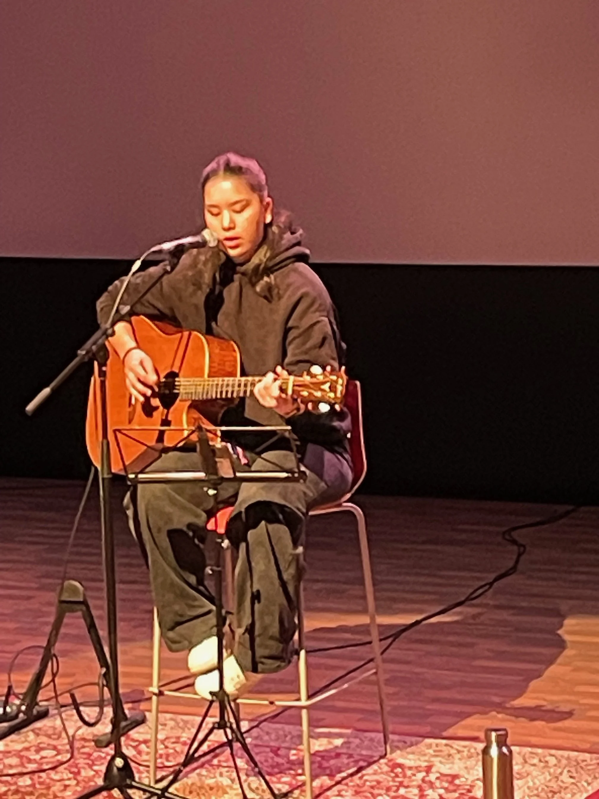
Nuunu, Greenland recording artist.
It was a narrated concert performed by a future Greenland recording artist named Nuunu. She played guitar and sang in the Greenlandic language. The narrator first discussed each song in English. Apparently, the Greenland music scene has been growing since the early 1970’s, when anti-Denmark government activists got together and brought their guitars. Nuunu sang about ten songs, starting with an early protest song by the artist Sume, titled Inuit Nunaat.
Each summer, Greenland Inuit communities would gather to trade, exchange stories and culture, and talk of their future. So, the next song was called Aasivik 79, with Aasivik being the Inuit word for summer settlement. Once Greenland received home-rule, the music changed, in part honouring their culture based on poems by northern Greenlander Ole Kristansen and, in part, rock influences. Hearing about the Greenland Inuit world through her beautiful voice moved me.
After getting completely lost again, I found the museum. Actually, it was a sort of ‘living museum’ within a small historic settlement area. Lots of exhibits on Inuit hunting, and fishing tools and practices going back eons. Quite well done. From there, a downhill walk to the ship.
Here is the link to Frederik Elsner singing Pinerrarissuaq with Ole Kristiansen. Have a listen: https://www.youtube.com/watch?v=rAg2UzGyaao.
August 18, 2025 - Davis Strait and Evigheds Fjord, Western Greenland
Zodiac captain leading a tour.
This morning, I travelled north up the Davis Strait. I’m currently at 53° west longitude. Further to the south, that longitude would place me near Gander, Newfoundland. There are whitecaps and the wind is blowing at about 10 km per hour.
After breakfast, I joined the other guests in receiving complimentary Arctic outdoor jackets and rubber boots. One of the staff handed me a jacket. It fit. So, I walked away. When leaving, I curiously noticed that the other guests were carrying cloth bags. One guest told me the jackets were in the bags and the jacket I was wearing was only for the purpose of fitting. I returned the jacket and got a bagged jacket. As I left, staff loudly announced to people in line that guests should not walk away with sample jackets.
Throughout the morning, the ship sailed north. We sailed up the Evigheds Fjord, a Danish term for Eternity Fjord – so named because it took an eternity for early seafarers to travel to its end.
I had an hour-long training session on how to enter and exit safely on a zodiac.
About an hour later, I hopped onto a zodiac with a captain and nine other guests. Most were from New Zealand and Australia. We motored to within 300 metres of a terminal and lateral glacier. The terminal glacier is about 12 thousand years old and is about 60 metres high. It had its origin 14 kilometres away as part of the Greenland Icecap, which is today about 450 metres deep. Several ice pieces calved off when we were there and fell into the water with a thunder-like crash. I’m glad we kept our distance.
Evigheds Fjord terminal glacier.
In contrast, the lateral glacier crept its way through several mountain peaks and was 20 thousand years old. It had a water fall at its base. It is neat that both emerged in the same bay.
On the way back to the ship, we passed a rookery of Black Guillemots and Kittiwakes. The Guillemots are classic sea birds and are able to dive to 150 metres depth to catch fish. They lay their eggs directly on steep rocks. Several weeks after hatching, the young bird is expected to fall to the water or crash on the rocks. Each year, they lay three eggs, and one bird typically survives. I suppose it’s a classic luck of the draw.
Our zodiac captain commented on the rain and overcast weather. She added that in Greenland this is actually good weather.
Tomorrow we will start the morning at the small village of Sisimiut, further north on the Davis Strait.
August 17, 2025 - Nuuk, Greenland
Air Greenland 330 Airbus.
I spent most of my day travelling to Nuuk, Greenland from Reykjavík, Iceland. The 1,400 km flight took about two hours via Air Greenland. I gained an hour, putting me two hours ahead of Toronto and a half hour ahead of Newfoundland. During the flight, I sat in a row behind two British academics who bonded. Their animated conversation covered a range of topics about matters that neither was qualified to discuss.
Air Greenland is an impressive organization. In addition to scheduled flights to Reykjavík and Copenhagen, Denmark, their fleet includes Dash 8 planes and many helicopters, offering both medivac and local transportation to Greenland’s smaller settlements. It owns tourist hotels, travel organizations, educational organizations, and more. Apparently, two new airports are planned for eastern Greenland, as they see lots of tourism opportunities.
Nuuk harbour.
In spite of being at the same latitude, Greenland is quite different from Iceland. Its 57,000 population is about a sixth the population of Iceland. We passed the University of Greenland, which is about the size of a Canadian high school. That said, I’m sure they graduate excellent students. Nuuk is situated on a rock outcrop and has about 20,000 residents. Almost all of the homes are multi-family town homes, with the exception of about ten apartment buildings.
In addition to a German Navy replenishment tanker and Danish HDMS Triton Ocean Patrol Frigate (F1411 and F358) in the harbour, its port is filled with fishing vessels. The harbour and local bays are also the home of small icebergs. On the bus from the airport to the ship, our indigenous guide stated that fishing and hunting is in full swing, and most families can count on a freezer full of fish and caribou all winter long.
Tomorrow I should be sailing north across the Arctic Circle. I can’t wait.
August 16, 2025 - Reykjavík, Iceland
Dawn breaking over the Labrador Sea.
One thing I learned on the five hour flight to Reykjavík is the sun is in the sky for about two and a half hours more than in Toronto. As I flew over the Labrador Sea approaching the coast of Greenland, the sun was peaking over the horizon at 2:30 am, Toronto time.
I got picked up from the airport by a driver who spent 45 minutes talking non-stop about what it was like to live in Iceland. It’s a peaceful country. Being just south of the Arctic Circle, Reykjavík is the most northern city of an independent country.
The police don’t carry guns – tasers and clubs instead. Free health care and education. They have great pride in their history and successfully being able to break away from Denmark. Apparently, Iceland athletes excel in soccer (football) and handball. My driver was quick to comment that handball is an Olympic sport. Who knew?
The downsides – It’s dark six months a year, and there isn’t much to do. Taxes are high. Also, with only 300 thousand residents and many families being able to trace their families back over 1000 years, the small population of Iceland poses a problem for relationships. She said after she goes on a date, she is able to put her social security number into a database to find out if she is dating a family member. I suppose the information helps to avoid an awkward morning conversation.
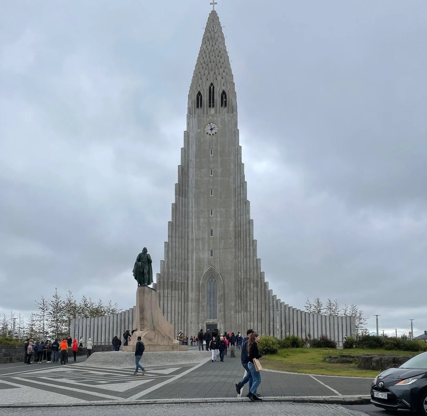
I did an afternoon walk to a couple of landmarks. It’s hard to avoid the steeple of the Hallgrimskirkja Church, as it’s Reykjavík’s tallest building.
I learned that in 2010, a local comedian named Jon Gnarr was elected mayor of Iceland. His party was called the ‘Best Party,’ and he ran on a platform of practicing corruption openly and fighting for a drug-free parliament. It’s no surprise that he only lasted for one term. But he did bring a lot of good policies related to sustainability and social justice. So, my walk included City Hall.
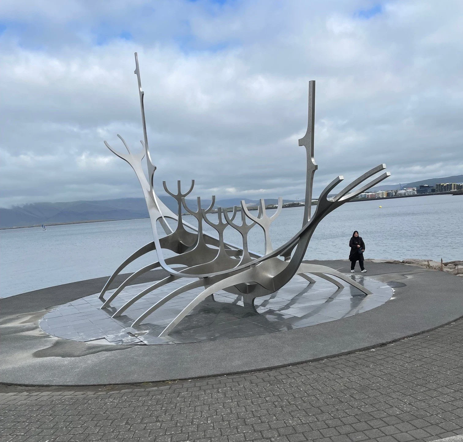
I also visited the National Gallery of Iceland. I sat in on a fantastic 34-minute visual art piece completed in 2010 called The Green Land. It was completed by Nuuk, Greenland resident Inuk Silis Hoegh. The city has lots of sculpture. Before my legs gave out, I had a chance to see an impressive waterfront sculpture called Solfarid (also known as The Sun Voyager).
Tomorrow, I continue my Northwest Passage voyage by flying to Greenland. I’d like to thank my cousin Bob Hardy for sharing Stan Rogers’ ballad on the search for a Northwest Passage. Have a listen: https://youtu.be/a9-ZGfidpow.
August 15, 2025 - Toronto
Fewer people have traversed the Northwest Passage than have climbed Mount Everest. Today, I’m starting that passage.
Map Credit: Ken McGoogan, Dead Reckoning; Harper Perennial, 2017.
Hurtigruten Expeditions, the tour group I’m with, worked hard to prepare me and the other passengers. Hurtigruten is also the expedition group I travelled with to Antarctica in January 2024. This time, instead of travelling with my daughter and her spouse, I’ll be travelling solo.
I attended two preparatory webinars. During the July webinar, the tour directors stated they were still waiting for the ice pack to melt enough for a complete passage. I suppose I’ll have more information to share in future days.
Dead Reckoning by Ken McGoogan; Erebus by Michael Palin.
I’ll also share the Arctic research I’ve undertaken in future blog posts. Two books - Dead Reckoning by Ken McGoogan, and The Erebus by Michael Palin (yes, that Michael Palin) - were quite informative. Both authors discuss many exploratory and rescue expeditions. Of note, they describe in detail the lost and then found Franklin expedition.
In September 2014, Parks Canada, Inuit officials, the Canadian Navy and Coast Guard, and others found their ship, the Erebus, in 36 feet of water. Graves of Franklin Expedition and McClure rescue expedition members were found on Beechey Island. That said, since the 1840’s, Inuit in the area had been generally aware of where the ship had sunk.
The current ice pack conditions, and so many historic exploration and rescue missions, got me thinking about whether I will make it through the passage. What happens if I and the other passengers get stuck in the ice? Apparently, in the mid-1840’s, Lady Franklin was quite influential in upper class circles. For many years, she raised funds and pressured the British government to launch several rescue expeditions… to no avail.
I asked several friends and my family if they would launch a rescue mission for me if the ship got stuck in the ice. Frankly, I was a bit surprised by the lack of enthusiasm. After the “we’ll do our best” comments, the conversations deteriorated to the matter of where my passwords are located. Perhaps I should have approached the rescue conversation a bit differently. I wonder if I should have made up a story about placing a large sum of money in a safety deposit box. I’d have the key in my pocket throughout the trip. Would this have been a better motivator?
The next post should be from Reykjavik, Iceland.